Low Pressure Area Forms Over Bay Of Bengal: MeT

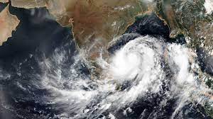
Hyderabad, Aug 18: The Low Pressure Area has formed at 0530 hours on Thursday over northeast and adjoining areas of east-central Bay of Bengal, Bangladesh-Myanmar coasts with the associated cyclonic circulation extending upto 7.6 km above mean sea level.
It is very likely to move northwestwards and become Well Marked Low Pressure Area during the next six hours, Meteorological Centre said today.
In a special weather bulletin here, it said the low pressure area continuing to move northwestwards, is likely to concentrate into a Depression by Friday morning over North Bay of Bengal and adjoining West Bengal & Bangladesh coasts.
Thereafter, it is likely to move west-northwestwards across Gangetic West Bengal, North Odisha, Jharkhand and North Chhattisgarh, the bulletin said.
The north-south trough runs from Rayalaseema to Comorin area across interior Tamil Nadu and extends upto 0.9 km above mean sea level.
Thunderstorm accompanied with lightning is very likely to occur at isolated places in few districts of Telangana from August 18 to 20. Southwest Monsoon has been weak in the state.
Rain occurred at isolated places in Telangana during the last 24 hours, the bulletin added.
With UNI Inputs….


