When The Cyclone DANA Will Landfall and Where?
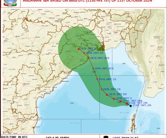
Balasore: The India Meteorological Department (IMD) has made a new update on the track of the cyclone. The storm is predicted to make landfall in Odisha. It is likely to hit North Odisha. The Meteorological Department has predicted landfall between Puri and Sagar Island. It may touch land by 24th night or 25th morning. It is predicted that the wind speed will be between 100 and 120.
According to the IMD, rainfall is likely to occur by the morning of October 22 and stormy conditions may develop over the East Central Bay of the Bay of Bengal by October 23. After that, by 24th October morning, it will move north westwards from Odisha-West Bengal coast towards northwest Bay of Bengal and make landfall between Balasore and Sagar Island.
At the time of landfall, the wind speed of the storm can reach 110 to 120 km per hour. Coastal Odisha will experience heavy to very heavy rain under its influence, said the Meteorological Department.
Under the influence of the storm, it will rain in most places on 23th, 24th and 25th of Oct. Under the influence of the storm, up to 110 mm of rain is expected in Balasore, Bhadrak, Jajpur, Kendrapara, Cuttack, Jagatsinghpur, Puri, Khordha, Ganjam and Gajapati districts. At this time, there is a possibility of very heavy rainfall of 30 and more than that cm in one or two places, especially in Jagatsinghpur, Puri, Ganjam districts.