Well-Marked Low Pressure Become More Severe On 24th Morning
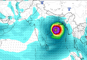
Puri: In the cyclonic environment in Odisha weather, a well-marked low pressure has turned into a depression this morning. It is now concentrated in the East Central Bay of Bengal. It will further condense and take the form of Cyclone Dana over the East Central Bay of Bengal tomorrow. After that, the storm will move north-west and become more severe on 24th morning. Manorama Mohanty, director of the Regional Meteorological Centre in Bhubaneswar, informed that the weather will change from tomorrow evening or night due to the impact of the storm.
The depression is now centered 730 km southeast of Paradip coast, 779 km south-southeast of West Bengal Sea Islands and 740 km south-southeast of Bangladesh’s Khepupara coast. It will gradually move west-northwest and become denser. It will take the form of a storm in the East Central Bay of Bengal tomorrow.
A severe cyclonic storm will cross over North Odisha and West Bengal coast from Puri to Sagar Island during 24 night and 25 morning. While crossing the coast, the wind speed can reach 100 to 110 km and the gust can reach 120 km, she added.