Cyclone Dana: Heavy Rainfall In Pockets Of Bengal Predicted Throughout Friday

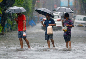
Kolkata, Oct 25: The Regional Meteorological Office in Kolkata has predicted continuing heavy rainfall in West Bengal for a major part of Friday as an after-effect of the landfall of Cyclone Dana that happened late Thursday night in neighbouring Odisha.
At the same time, the office has also said that the intensity of the rainfall will start receding from Friday night and the situation is expected to be more or less normal from Saturday morning.
“Heavy showers started late Thursday night as an impact of the landfall; at several pockets in south Bengal, especially in the coastal belts. The intensity of the rains increased after the landfall process was completed early Friday morning as its after-effect,” the Regional Meteorological Office said.
As per the records of the office, maximum rainfall from Thursday night till Friday morning was at Diamond Harbour in South Parganas district at 93 mm, followed by Kalaikunda in West Midnapore district at 90.6 mm, Sagar Islands in South 24 Parganas district at 89.6 mm, and Haldia in East Midnapore district at 80 mm. The rainfall during the same period at the state capital of Kolkata was comparatively lower at 42.7 mm.
Meanwhile, four districts in south Bengal, namely South 24 Parganas, East Midnapore, West Midnapore, and Jhargram are continuing under red alert, following the prediction of maximum rainfall along with high wind speed there.
The Regional Meteorological Office has predicted the wind speed to hover around 60 kilometres an hour in the coastal belts of the state on Friday. At the same time, orange alert is continuing in Kolkata along with Howrah, Hooghly, North 24 Parganas, Purulia and Bankura. However, not much rainfall has been predicted for the districts in north Bengal.
Restrictions on the fishermen from going to the deep-seas for fishing will continue on Friday and depending upon the situation, might be lifted on Saturday.
–IANS


