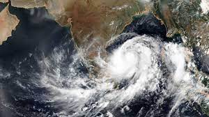
Low Pressure to trigger heavy rains in Odisha for five days- IMD

Bhubaneswar,Sep 5: A low pressure area has formed over the Northwest and adjoining Westcentral Bay of Bengal off the south Odisha-north Andhra Pradesh coasts on Tuesday.
IMD sources said the low pressure area was formed under the influence of Monday’s cyclonic circulation over the northwest Bay of Bengal and adjoining areas, with the associated cyclonic circulation extending up to 7.6 km above mean sea level and tilting southwestward with height. It now persists over the same region.
It is very likely to move nearly westward across south Odisha and south Chhattisgarh during the next 24 hours.
IMD sources further said the western end of the monsoon trough runs along the foothills of the Himalayas, and its eastern end now passes through Najibabad, Lucknow, Satna, Raipur, and thence southeastwards to the centre of the low pressure area over the northwest and adjoining westcentral Bay of Bengal off south Odisha-north.
Under its impact, light to moderate rain or thundershowers are very likely to occur at most places in the districts of Odisha for the next five days.
Meteorological sources said the average rainfall recorded in Odisha during the last 24 hours was 16.7 mm, while the state’s average rainfall recorded from September 1 to September 5 was 50.1 mm, against the September monthly average of 231.9 mm.
The highest rainfall of 142.4 mm was recorded in the last 24 hours in Belaguntha Block of Ganjam District. At least three blocks, namely Belguntha in Ganjam district, Siluapada, and Khunta in Mayurbhanj district, recorded more than 100 mm of rainfall in the past 24 hours.


